Channel Country
South West Queensland September 2007

|
South West Queensland September 2007 |
|
Jundah is situated on the Thomson River which joins the Barcoo River and they become Coopers Creek from there and flow towards Lake Eyre when there is sufficient flood waters. This is a strange thing where 2 rivers join to become a creek. Charles Sturt the explorer named it Coopers Creek because he didn't feel that the river status was justified as "There was no current". He should have seen it when the flood waters were surging along....blind freddie would have noticed a current then.
So into Jundah for fuel and bread and some Bundy rum and Wine supplies....these campfire nights are really hard work. The lovely lass at the Jundah Pub engaged us in conversation and discovered that we did short term relief management in motels....well she nearly jumped out of her skin tight jeans with this news flash and then asked if we did pubs...in particular in Jundah....only one pub in this town so we didn't need to be Rhoades Scholars to work out her drift.
We lunched and topped up our water tanks in Jundah and checked out the Thomson River Camps, but they didn't excite us too much...steep banks and just not picturesque enough to tempt us.....so we took the river road to Windorah. The river road is unsealed and a lot more interesting than the sealed developmental road.....We crossed the Thomson so many times at little causeways and lots of wildlife to be seen. Those causeways would be wild torrents in times of flood.
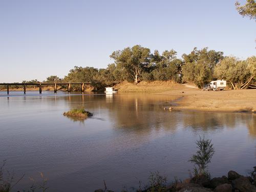
The river road brought us out 10 K's East of Windorah at the Cooper Creek crossing. Lots of camps to be had here and the waterholes were very nice. We chose to drive down the bank and camp on the sand next to the waterhole...magic....however if you do this, always keep an ear to the local weather news for rain to the North. This can cause flash flooding and without seeing a drop of rain, you could be washed away. Did you know that most recorded deaths in the desert are attributed to floods.
|
|
|
We put in the yabbie traps but did no good ....something very strong and hungry chewed through one of our traps and made a big hole in the mesh...a local thought it might be an eel...I thought a water rat might be the culprit....we'll never know I guess...
|
|
|
|
|
|
We could still be
camped at this spot, however the season was getting warmer and September was
comfortable, but we could feel the heat was just around the corner....so after 3
days here we headed East to Quilpie for fuel and lunch. The best hamburger in
Quilpie is at the roadhouse on the Eastern side of town. There's also a nice
camp (Lake Houdramann) about 6 k's East of Quilpie too.....we camped there last
year on our way out to the Red Centre, however this time we were heading South
to Thargomindah via Toompine.
On our way to Quilpie we spotted 3 Little Pigs..hey that would be a good story
book title....wow...these flashes of brilliance just come to me...like a
gift....
|
|
|
On our way from Quilpie to Toompine we spotted "Old Man Emu" who was caring for his 13 little chicks.... a dedicated dad while his promiscuous spouse is off with the boys.....Lucky girl..
So on to Toompine Hotel where you can get a cold drink and a hot meal and have a chat with Doris the Donkey and the baby camel and the goats and.....wow these folks really do have a lot of pets. Next to the pub is the community hall where you can plug into power and have a hot shower all for free...supplied by the council for the use of travelers and locals alike. The sporting club have their trap shooting range here and while we were camped in front of the hall a few tenters were camped on the concrete shooting tracks oblivious to what they were.
|
|
|
Well we could go to Thargomindah on the most traveled route, however the old river road looked more interesting...so...off we go....